📡 Sonar Coverage Calculator
Calculate beam width, coverage area, and detection range for any sonar setup — in imperial & metric
| Beam Angle | 10 ft (3 m) Depth | 30 ft (9 m) Depth | 100 ft (30 m) Depth | 300 ft (91 m) Depth |
|---|---|---|---|---|
| 5° (Narrow) | 0.9 ft / 0.3 m | 2.6 ft / 0.8 m | 8.7 ft / 2.7 m | 26 ft / 8 m |
| 12° (CHIRP) | 2.1 ft / 0.6 m | 6.3 ft / 1.9 m | 21 ft / 6.4 m | 63 ft / 19 m |
| 20° (200 kHz) | 3.6 ft / 1.1 m | 10.7 ft / 3.3 m | 36 ft / 11 m | 107 ft / 33 m |
| 45° (Mid) | 8.3 ft / 2.5 m | 24.9 ft / 7.6 m | 83 ft / 25 m | 249 ft / 76 m |
| 60° (83 kHz) | 11.5 ft / 3.5 m | 34.6 ft / 10.5 m | 115 ft / 35 m | 346 ft / 105 m |
| 90° (Wide) | 20 ft / 6.1 m | 60 ft / 18.3 m | 200 ft / 61 m | 600 ft / 183 m |
| Species | Typical Depth Range | Recommended Freq. | Suggested Beam | Coverage Width |
|---|---|---|---|---|
| Largemouth Bass | 2–25 ft (0.6–7.6 m) | 83–200 kHz | 40°–60° | 1.5–25 ft (0.5–7.6 m) |
| Walleye | 15–40 ft (4.6–12 m) | 200 kHz / CHIRP | 20°–35° | 5–25 ft (1.5–7.6 m) |
| Trout (Lake) | 20–80 ft (6–24 m) | 200 kHz | 20° | 7–29 ft (2.1–8.8 m) |
| Catfish | 20–60 ft (6–18 m) | 83 kHz | 60° | 23–69 ft (7–21 m) |
| Panfish / Crappie | 5–20 ft (1.5–6 m) | 455 kHz / 800 kHz | Down Scan | 2–8 ft (0.6–2.4 m) |
| Striped Bass | 10–60 ft (3–18 m) | 83 kHz | 60° | 11–69 ft (3.4–21 m) |
| Northern Pike | 5–30 ft (1.5–9 m) | 200 kHz | 20°–30° | 2–16 ft (0.6–4.9 m) |
| Bluefin Tuna | 100–600 ft (30–183 m) | 50 kHz | 45° | 83–498 ft (25–152 m) |
| Type | Typical Angle / Range | Max Effective Depth | Best Application | Clarity |
|---|---|---|---|---|
| Single Cone | 20°–60° cone | 1,500 ft / 457 m | General freshwater | Good |
| Dual Beam | 20° + 60° combo | 1,500 ft / 457 m | Versatile all-depth | Very Good |
| Side Scan | Up to 400 ft each side | 300 ft / 91 m | Structure search | Photo-like |
| Down Scan / DI | 1° wide, sweeping | 300 ft / 91 m | Vertical detail | Excellent |
| CHIRP | Variable 5°–20° | 3,000 ft / 914 m | Offshore / deep | Superior |
| 360 Imaging | Full 360° surround | 200 ft / 61 m | Shallow docking/fishing | Very Good |
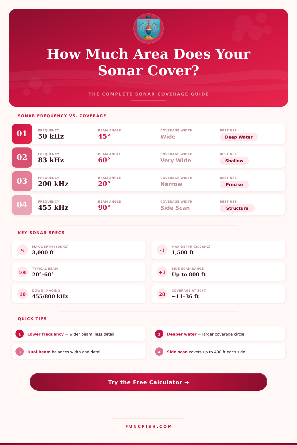
Lower frequencies (50–83 kHz) produce wider cone angles and scan more bottom area per pass, but with less resolution. Use them for open-water searches. For precise fish identification and bottom structure detail, switch to 200–455 kHz with a narrower beam.
At 5 mph (8 km/h), a sonar unit pings roughly 15–20 times per second. Coverage width at the bottom determines your effective strip width per pass. To calculate total area scanned during a fishing session, multiply coverage width by total distance traveled.
The coverage of the sonar depend upon the shape of the sonar cone. The shape of the sonar cone is the area that the sonar beam illuminates. As the beam travel further into the water, the cone of the sonar beam expands.
Therefore, the farther the beam travels, the more wider the cone becomes. For these reasons, it is important for an individual to understand the width of the sonar cone. Otherwise, the coverage of the sonar may leave gaps in the coverage of the area where the sonar is to be utilized.
How Sonar Beam Width Affects Coverage
If an individual leaves gaps in the coverage of the sonar beam, then the sonar will miss both structures and fish in those gaps. The angle of the sonar beam create the width of the cone of the sonar beam. For example, a sonar beam that has an eight-degree angle is a narrow beam of sonar.
Such a narrow beam of sonar is useful in reading the details of a small area. In contrast, a sonar beam with a thirty-five degree angle is a wide beam of sonar that covers a larger area of the lake or water body bottom. However, because it is so wide, it dont provide the same level of detail as the narrow beam of sonar.
The width of the sonar beam at the bottom of the water is referred to as the footprint of the beam. The size of this footprint is the most importance measurement of the boat lanes in the water. The depth at which the boat is traveling is one of the primary factor that determines the size of the footprint of the sonar beam.
For example, if the boat is using a sonar beam with a twenty degree angle, at a depth of thirty feet, the footprint of the beam will be approximately eleven feet in width. This footprint continues to expand as the depth of the boat increase. For these reasons, boat lanes may need to be adjusted according to the depth of the area in which the boat will be traveling.
If boat lanes are to be maintained at the same distance from each other, but the depth of the water is increasing, the boat lanes may end up to far apart from one another; there will be gaps in the sonar coverage. The height of the transducer that emits the sonar beam can also impact the coverage of the sonar beam. The transducer is usually located a certain distance from the waterline.
The distance between the transducer and the bottom of the water area may impact the width of the footprint of the sonar beam. If an individual does not account for this distance, the individual may miscalculate the footprint of the sonar beam. Additionally, factors like the movement of the boat due to the wind or currents may impact the boat lane.
If the boat lanes become different than those that is planned, the sonar coverage wont be as precise as it could be. An individual can use various measurement of the sonar beam to calculate the coverage of the beam. For example, the bottom diameter is the width of the beam at the bottom of the water.
The footprint area of the beam is the total area of the footprint that the beam illuminates. Safe spacing is the distance between each boat lane. Additionally, there is an area referred to as the overlap; this is the area in which the footprint of two different passes of the boat overlap.
The individual should ensure the overlap; otherwise, there may be a gap in the coverage of the sonar beam. For example, if an individual is passing through an area with many weeds, the overlap may need to be increased to ensure that the sonar beam does not miss any fish in those weeds. Sonar beam can have various settings according to the type of task that the boat is to perform.
For instance, a narrow beam may be used if the goal is to locate specific details about structures in the water. However, a wide beam may be used for larger area. In areas with many weeds, however, the overlap between the footprints of the sonar beam can be increased; the weeds may interfere with the sonar beam.
In open water, however, the boat may use wider boat lanes. Therefore, if an individual is to fish in areas without structures, the lanes can be wider. In areas with drop-offs, however, the individual should use smaller, more tight boat lanes so that the sonar coverage of the water floor is continuous.
An individual can plan the use of the sonar beam according to a grid of boat lanes. The lanes can be made tight or wide according to the type of precision that is required of the sonar beam. For example, if an individual is fishing in a river, the current may move the boat.
An individual must account for this in planning the boat lanes. Additionally, if an individual is fishing in depths of water greater than a few feet, the individual must account for the increased size of the footprint of the sonar beam. By planning these variables in advance, an individual can ensure that the sonar beam will cover the water floor in a complete manner, and the beam will not miss any structure or fish.