Summer Thermocline Location Calculator
Estimate the top, center, and bottom of the summer thermocline, then match that layer to oxygen limits and target species temperature preferences.
📌Scenario presets
⚙Summer lake profile inputs
Summer thermocline estimate
Calculation breakdown
🌡Profile method grid
Weighted thermometer
Dissolved oxygen probe
Castable sonar
Logger chain
🐟Species comparison grid
Largemouth bass
Often rides the upper edge when bait and cover overlap the thermocline.
Smallmouth bass
Usually tolerates a cooler center band around rock, breaks, and open-water bait.
Walleye
Frequently uses the lower light edge if oxygen remains above its comfort floor.
Rainbow trout
Needs cooler water and higher oxygen, so the safe band can be narrow in summer.
Kokanee salmon
Tracks cool oxygenated water and may suspend near the center or lower edge.
Striped bass
Follows shad across channel basins where temperature and oxygen still overlap.
Northern pike
Uses cool breaks near weeds, especially where the thermocline brushes structure.
Channel catfish
Can roam warmer water, but low oxygen still limits deep summer basin use.
📊Thermocline reference tables
| Summer signal | Weak layer | Moderate layer | Strong layer |
|---|---|---|---|
| Surface to deep temperature gap | Less than 6°F / 3.3°C | 6-15°F / 3.3-8.3°C | More than 15°F / 8.3°C |
| Maximum basin depth | Under 15 ft / 4.6 m | 15-35 ft / 4.6-10.7 m | Over 35 ft / 10.7 m |
| Clarity influence | 0-3 ft / 0-0.9 m visibility | 4-8 ft / 1.2-2.4 m visibility | 9+ ft / 2.7+ m visibility |
| Wind mixing effect | Frequent wind weakens the break | Light wind leaves a broad layer | Stable heat tightens the break |
| Reading method | Suggested spacing | Useful output | Adjustment used |
|---|---|---|---|
| Weighted thermometer | Every 5 ft / 1.5 m | Temperature break depth | Moderate error allowance |
| DO probe | Every 3 ft / 0.9 m | Oxygen-safe lower edge | Highest confidence |
| Castable sonar | Every 4 ft / 1.2 m | Bank or kayak profile | Extra drift allowance |
| Logger chain | Every 2 ft / 0.6 m | Precise gradient shape | Smallest error allowance |
| Marked anchor rope | Every 6 ft / 1.8 m | Quick manual check | Widest search window |
| Species | Summer preference | Oxygen floor | Thermocline relation |
|---|---|---|---|
| Largemouth bass | 68-82°F / 20-28°C | 4.0 mg/L | Upper edge, cover, bait |
| Smallmouth bass | 62-75°F / 17-24°C | 5.0 mg/L | Center to upper edge |
| Walleye | 55-70°F / 13-21°C | 5.0 mg/L | Cool side with light break |
| Rainbow trout | 50-65°F / 10-18°C | 6.0 mg/L | Cool oxygen overlap |
| Striped bass | 60-74°F / 16-23°C | 5.5 mg/L | Channel bait layer |
| Channel catfish | 72-86°F / 22-30°C | 3.0 mg/L | Above low-oxygen bottom |
| Condition | Layer top effect | Layer strength effect | Fishing interpretation |
|---|---|---|---|
| Clear water | Moves deeper | Usually stronger | Check deeper suspended marks |
| Stained water | Moves shallower | Can be weaker | Focus upper breaks first |
| Two windy days | Broadens layer | Lowers score | Search wider around the estimate |
| Hot stable week | Tightens layer | Raises score | Edges become more repeatable |
| Low deep oxygen | May not move top | Cuts lower edge | Fish above oxygen boundary |
💡Calculation tips
Tip: Recheck the profile after a strong wind or cold rain. Summer layers can shift several feet when the upper water mixes.
Tip: Treat dissolved oxygen as the lower boundary. A perfect temperature below the oxygen edge is usually not a reliable fish-holding depth.
If you’ve been frustrated by fishing with no action, you know what I’m talking about. Fish don’t shows up on your screen. Or they’re there, but they won’t come down deep enough to touch anything. The water temp might be right for walleyes or bass, but fish suspend so tight you can’t see them on your sonar. They’re suspended in a very thin layer you can’t seem to get through.
This layer is called the thermocline. It doesn’t exist to most other people, but it will make or break summer fishing. It’s an invisible wall between catchable and not. And a lot of guys just guess at its location.
How to Find Fish in the Thermocline
The tool takes into account wind history, water clarity, and temperature changes. It also consider how lakes work. Then it spits out a map showing the exact layer of water where bait suspends.
So what does this all mean? A thermocline isn’t one line; it’s an area. It’s an area where the temperature change rapidly over a short vertical distance. The surface gets warmed by the sun (epilimnion), the bottom stays cold (hypolimnion) and then there’s a quick transition from warm to cool. That’s the thermocline or metalimnion.
A lot of times, it’s the floor for some fish and the ceiling for others. It’s a place they can get comfortabley with the temperature while still getting enough oxygen. So if it’s too far down, there won’t be much oxygen but if you’re on top of them, it’ll be too bright and maybe even hot. You want to find the sweet spot in the middle.
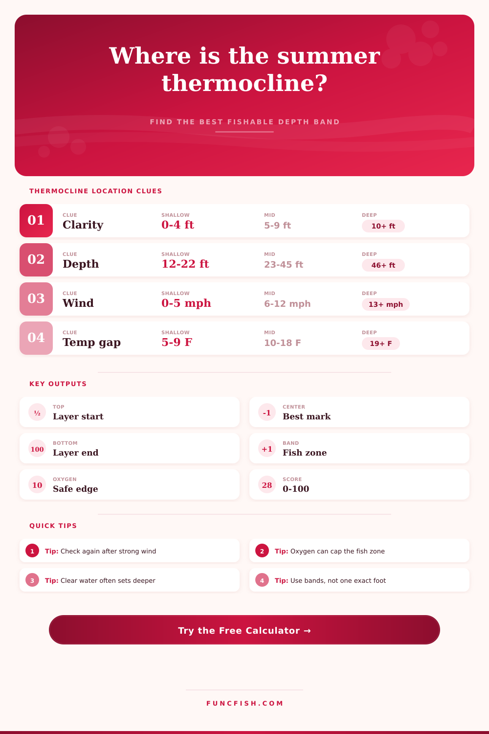
Your input matters a lot here. To calculate the gradient it looks at both deep temperature and the surface temperature. That’s because the depth of heat absorption is driven by light penetration. When there is clear water, sunlight penetrates deeper which pushes the thermocline downward. In stained water, the heat is absorbed closer to the surface so the layer stays higher in the water column. That is why two lakes with the same temperature can have thermoclines at different depths. You’ll notice from the reference table that visibility moves the layer up or down a few feet.
Another consideration are wind. Wind mixes up surface water and breaks up the layer. Two days of consistent wind will weaken the thermocline and make it more broad. That influences confidence score too.
Within the zone, it depends on what species you’re looking for. For example, largemouth bass will commonly hold right up against cover on the top edge of the zone. Smallmouth bass typically move toward the cool middle of the zone, particularly around rock structure. Walleye can handles slightly cooler water than largemouth but still need some oxygen. Trout/kokanee salmon prefer even colder water but also need more oxygen. Their safe band is even smaller.
The output from the calculator will be a depth range based off the species you want to catch. That’s not one number. It’s a range with both an oxygen limit and a thermal requirement in mind. People sometimes make mistake of thinking only about oxygen requirements, ignoring temperature. You could have a great temperature but no oxygen and it won’t matter.
A confidence score shows how reliable that estimate is. Sharp layer with consistent data = High Score. Weak layer or contradictory inputs = Low Score. Use this as an indicator for where you spend time searching deeply versus how far from the spot you should of looked.
Accuracy: How accurate are those estimates? A simple weighted thermometer gives us the basics, while a dissolved oxygen logger chain or probe will give you a sharper profile. Your selected method dictates the tool’s estimated errors. This lets you know if there’s some wiggle room in your search.
Summer fishing. Be observant and patient; the layers changes based on the sun, wind, and daily temperature changes. What was marked in the morning might not be there in the afternoon. Always check back if a cold front hits or if they get hit by a storm. And remember, the water column is dynamic.
Having a starting point helps you narrow down your search. A calculator does that. It removes the guesswork and lets you focus on finding fish. When you finally find the thermocline, everything else make sense. From that point forward, you’re no longer fishing a certain depth; now you’re fishing the break. That’s what separates a good day from a bad day. The thermocline is there; you just have to find it.