Thermocline Depth Estimator
Estimate the lake layer where temperature drops fast, then translate that depth into a fishable band, oxygen caution, and probe target.
📌Fishing scenario presets
⚙Thermocline settings
Thermocline estimate
Full breakdown
📋Method confidence grid
Temp Probe
Sonar Line
Secchi + Map
Visual Only
📊Thermocline reference tables
| Lake type | Typical cline cue | Depth share | Oxygen note |
|---|---|---|---|
| Clear natural lake | 2.2x Secchi depth | 32-48% of basin | Usually fair above line |
| Deep highland reservoir | 2.5x Secchi depth | 35-55% of basin | Watch bait and current |
| Stained reservoir | 1.8x Secchi depth | 24-42% of basin | Risk rises below line |
| Fertile bowl lake | 1.5x Secchi depth | 18-35% of basin | Low oxygen can start early |
| Shallow weedy lake | Wind-mixed often | 15-30% of basin | May not hold a clean break |
| Cold trout lake | 2.3x Secchi depth | 35-60% of basin | Best lane often near cold edge |
| River-run reservoir | Current breaks layers | 20-38% of basin | Check inflow and channel |
| Thermal stage | Base depth | Surface temp clue | Fishing translation |
|---|---|---|---|
| Spring warming | 8-16 ft | 55-66 F | Weak break, fish roam |
| Early summer setup | 14-24 ft | 66-76 F | Edges begin to stack |
| Midsummer stratified | 18-34 ft | 74-86 F | Fish the top half first |
| Late summer check | 16-32 ft | 76-90 F | Probe oxygen below it |
| Fall turnover window | Variable | 58-70 F | Break may smear or vanish |
| Target | Starting band | Search width | Extra output to watch |
|---|---|---|---|
| Bass | Upper edge to 4 ft above | Medium | Hard spots and bait balls |
| Walleye | Thermocline plus edge | Medium | Wind-blown basin breaks |
| Trout | Cold side of upper band | Narrow | Temperature probe reading |
| Kokanee | Stable lane through band | Narrow | Trolling depth consistency |
| Crappie | Above low oxygen edge | Wide | Brush height vs band |
| Striped bass | Bait near upper cline | Wide | Open-water bait depth |
| Pike | Weeds near cooler edge | Medium | Green weed depth |
| Catfish | Above oxygen caution | Wide | Channel edge and basin lip |
💡Practical checks
Tip: If sonar marks vanish below the estimated line, treat the lower edge as an oxygen boundary and move presentations up.
Tip: A clean thermocline usually shows a fast temperature drop over a few feet, not a single exact shelf.
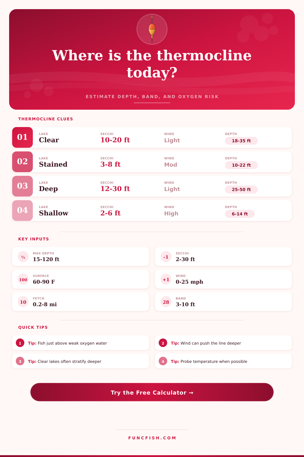
A thermocline is an narrow band of water where the temperature drops quick. A thermocline is a layer of water where the property of the water change, such as the amount of oxygen, the presence of bait, and the presence of predators in that layer of water. Most anglers experiences thermoclines in the summer months when the fish relocate or when the fish cease to appear on electronic fish find screens.
Anglers cannot rely upon the depth of thermoclines as a number when targeting fish with lure. The depth of thermoclines depend on several different factor. One of the factors that impacts the depth of the thermocline is the depth of the basin in which the fish live.
How thermoclines affect fishing
The depth of the thermocline cannot go deeper into the basin than the deepest part of the basin floor. Another of the factors is the clarity of the water. A Secchi depth measures the clarity of the water and determines how far sunlight can penetrate into the water.
Sunlight determines how warm the surface of the water can be. The speed of the wind that blows into the water and the number of days that the wind has been blowing will impact the depth of the thermocline because the wind will mix the water layer. The temperature of the surface of the water will indicate whether the lake is building or losing it’s thermocline.
These factors will impact the depth of the thermocline independently of each other, yet all of these factors will have an impact upon the thermocline that the angler desire to target. An estimator will use each of these different variables to calculate the depth of the thermocline. The estimator will take the measurements of the water (clarity, wind, basin depth) and create a band of depth for the thermocline.
The estimator will not provide the anglers with a single depth measurement for the thermocline. Instead, it will provide the mixed-layer depth of the thermocline and an oxygen-risk flag. The mixed-layer depth will show the angler how far the wind stirred the water in the lake.
The oxygen-risk flag will indicate to the angler if the amount of oxygen in the water is low enough that the fish has abandoned the area beneath the thermocline. If the oxygen-risk flag is high, then the thermocline will act as a ceiling for the fish rather than a target. Depending upon the type of fish that the angler desires to catch, the fish will react differently to the thermocline.
Anglers will find bass near the upper edge of the thermocline because that is where they will ambush the bait. Anglers will find walleye along the windward side of the thermocline because that portion of the thermocline has more bait than the other side of the thermocline. Trout will be found in the colder water beneath the thermocline yet not in area with low amounts of dissolved oxygen in the water.
Thus, the lower edge of the thermocline will be the limit for trout in the water. Although the thermocline estimator doesnt make up for the use of a temperature probe or electronic fish find screens, the estimator will narrow the angler’s search within the water. A thermocline is not a shelf that anglers can target.
Thermoclines do not exist as thin lines within the water column. Instead, the thermocline exists over several feet within the water and the strength of the thermocline within that area change with the weather. If sunny days are featured in a planning schedule for fishing the thermocline, then the thermocline will be stronger and more thin than on a windy day with rain.
The thermocline estimator allow for a condition setting for these variables so that the estimations will change within the same lake with the same depth and water clarity. With the summer season comes late summer and a drop in the amount of oxygen that lives within the water. This drop in the amount of oxygen is due to the decaying organic matter in the water.
As a result, the oxygen that is present in the water beneath the thermocline is less than in the upper portion of the water column. The oxygen-risk output of the thermocline estimator will alert the angler of these low amount of dissolved oxygen in the water. If the oxygen risk level is high, then the area for fishing will move upward within the water regardless of the temperature of the thermocline.
Due to the complexity in calculating the thermocline, reference tables exist to assist those anglers that find themselves unable to perform the calculations themselves. These reference tables indicate different types of lakes and how those lakes changes their thermocline according to the season. A method-confidence grid is provided to remind anglers that a temperature probe will reveal a more accurate thermocline than the visual estimation of the thermocline.
If anglers decide to use a temperature probe to find the thermocline, they can employ the narrow search width from the thermocline estimator. The main value of a thermocline estimator is that it will allow anglers to focus on a specific portion of the water column. Anglers will have to lower their lure into the water and they will have to use electronic screens to find the fish.
Nevertheless, using the thermocline estimator will allow anglers to limit the portion of the water column that they will search for fish. Using a narrow portion of the water column will allow anglers to make fewer cast into the water to find the fish. Thus, the thermocline estimator will allow anglers to spend more time within the portion of the water where the targeted species of fish live.