Rule of Twelfths Tide Calculator
Estimate tide height, twelfths stage, local flow strength, and whether a fishing spot has enough water for the technique you plan to use.
📌Scenario presets
⚙Tide and fishing inputs
Tide stage forecast
Full breakdown
📋Fishing zone data grid
Open flat
Marsh creek
Inlet throat
Dock line
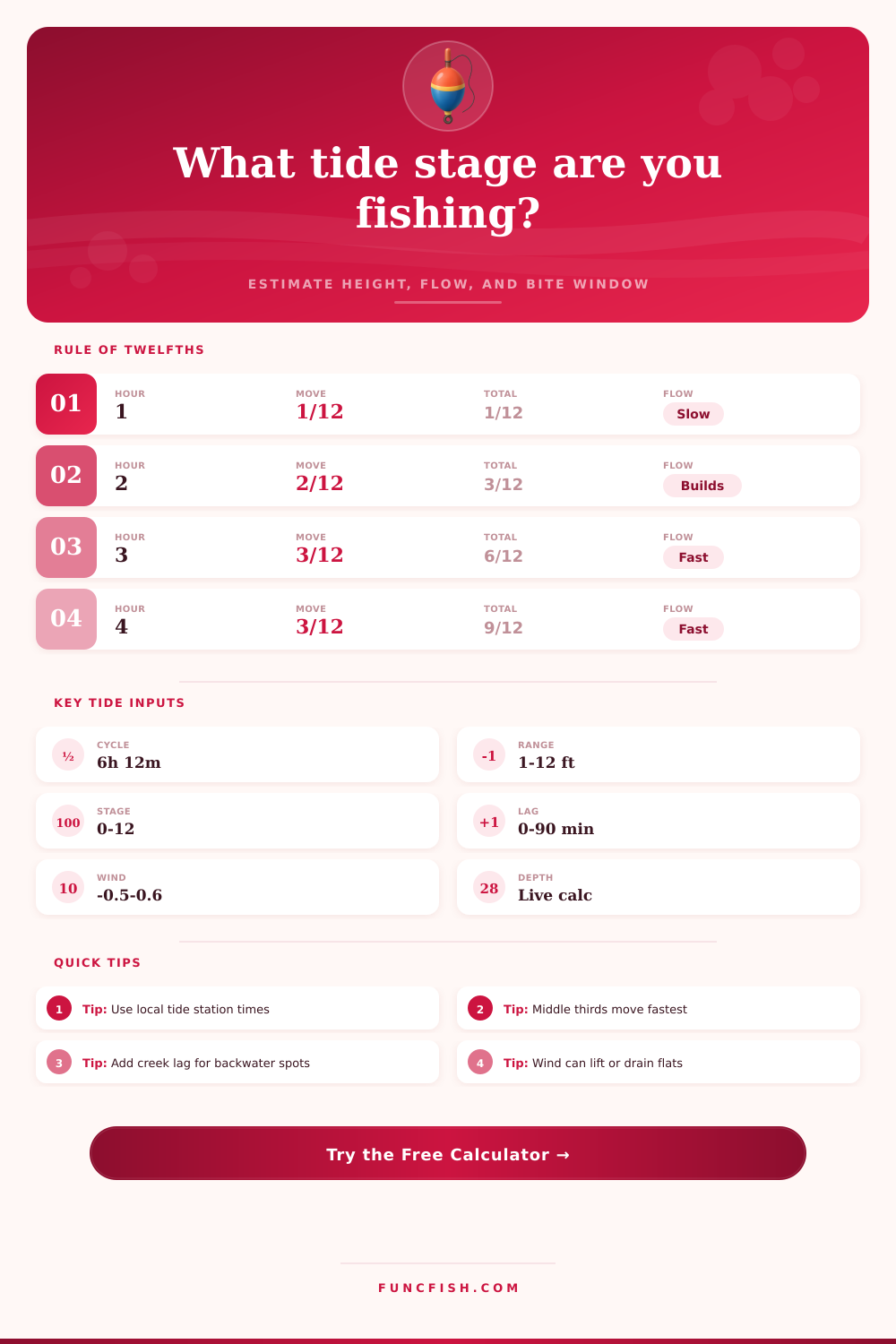
📐Rule of twelfths reference
| Time block | Movement in block | Cumulative rising tide | Typical fishing read |
|---|---|---|---|
| First sixth | 1/12 of range | 1/12 | Slack turning to slow flow |
| Second sixth | 2/12 of range | 3/12 | Current begins to organize |
| Third sixth | 3/12 of range | 6/12 | Fastest middle-stage movement |
| Fourth sixth | 3/12 of range | 9/12 | Fast movement continues |
| Fifth sixth | 2/12 of range | 11/12 | Flow softens toward the turn |
| Sixth sixth | 1/12 of range | 12/12 | High or low slack is close |
| Scenario | Preferred stage | Minimum water | Flow target |
|---|---|---|---|
| Redfish flats | 4/12 to 10/12 rising | 1.0 ft / 0.30 m | Slow to moderate |
| Striped bass inlet | 2/12 to 8/12 falling | 3.0 ft / 0.91 m | Moderate to strong |
| Flounder edge | 3/12 to 9/12 either way | 1.5 ft / 0.46 m | Moderate |
| Snook dock line | 4/12 to 9/12 moving | 2.0 ft / 0.61 m | Moderate |
| Surf trough | 3/12 to 8/12 rising | 2.5 ft / 0.76 m | Steady sweep |
| Bridge piling | 2/12 to 7/12 falling | 4.0 ft / 1.22 m | Strong but fishable |
| Zone type | Station lag | Flow multiplier | Practical note |
|---|---|---|---|
| Open flat | 5 to 15 min | 0.8 | Depth matters more than speed |
| Marsh creek | 25 to 50 min | 1.2 | Lag can be larger deep in the marsh |
| Channel edge | 5 to 20 min | 1.1 | Food funnels along the break |
| Inlet throat | 0 to 10 min | 1.6 | Current may outrun light tackle |
| Bridge piling | 5 to 15 min | 1.4 | Eddies can create local slack pockets |
| Surf trough | 0 to 10 min | 1.0 | Wave setup can change actual depth |
💡Practical calculation checks
Tip: The rule of twelfths is an estimate for a regular tide curve. Local wind, river discharge, inlet shape, and barometric pressure can shift the water height.
Tip: For backwater fishing, subtract the local lag from the station elapsed time. A spot 35 minutes behind the station may still be in the prior flow block.
Tide fishing involves comparing a data on a tide chart to the actual movement of water in a particular location. Even if the tide chart note a high tide at a particular time, the water in a particular creek might be low because the water has to travel through channels and over oyster bar before it can reach the creek. That difference between the tide chart and the actual water movement is when the rule of twelfths are applied to calculate how the water in those areas moves.
The calculator will help you find the data needed to perform these calculations after you input the local times and fishing spot detail. The rule of twelfths calculates the tides every six hours into six different part. The first and last parts of the tides have only one twelfth of the total movement of water, while the middle two parts has three twelfths each.
How to Use a Tide Calculator for Fishing
The rule of twelfths calculations assumes that the water movement is slow at first, then rapid in the middle portion of the tide, and then slow again at the end of the cycle. The calculator use the rule of twelfths and allows you to adjust for wind or river movement. Adjustments for wind are necessary because the wind can move the water in toward the land and add inches to the water level that the tide chart may not show.
The location that you select in the calculator define where you will be fishing. Different fish species requires different depths of water. For instance, a redfish can be fine in one foot of water, but a striper might require the water to be three feet deep before it will begin to move in the current.
Based off the minimum depth of water that a particular species of fish require, the calculator will produce a percentage score that reflect the fishing conditions at your fishing spot. If the percentage are in the low eighties, the fishing is likely to be good. If the score is below sixty, then the depth of the water are incorrect or the current is too slow for the fish to be moving.
The lag time for the tide chart is the amount of time that the tide in a main tide station change compared to the time that the tide at your fishing spot change. For instance, a tide station in a main bay might show that the tide is changing two hours before the creek in a marsh changes direction. You have to account for this lag time in the calculator so you dont arrive at your fishing spot too early.
The lag time also apply to ebb tides for spots that take time to drain of the fish. Wind and barometric pressure will change the levels of water in the ocean and bay but will not factor into the rule of twelfths calculations. Offshore breeze might lower the water in the bay below the level of the low tide chart.
Breezes that blow from the ocean toward the bay will make the water level higher then the high tide chart would state. Although the rule of twelfths calculator will provide the predicted tide, you should also use it to observe the wind and the sky to determine the actual water level at your fishing spot. People sometimes make mistake when using the rule of twelfths.
People often do not account for the lag time between the tide station and there spot. They do not consider the elevation of the bottom of the fishing spot. If you do not input the bottom elevation of your spot, the calculator will report a low score for fishing condition.
Some people also do not account for the fact that the middle two parts of the tide have the most fastest movement of water in the tidal cycle. These people might show up at there spot, expecting the water to move quickly at their spot, only to find that the water level is moving slow. The tide fishing calculator come in handy when fishing conditions are between ideal and marginal.
For example, the water depth is correct, but the current in the water is building. Or the spot is the correct depth for the fish you are trying to catch, but the direction of the current is the wrong way. The calculator can give a score for each of these condition so you can make a more better decision about whether to wait for the tide to change direction or move to a different spot altogether.
This calculator helps you determine each of these variable and makes it easier for you to make an informed decision about your fishing spot.